Lab 8

The Station Fire in Los Angeles in 2009 had a huge impact on the city and its people. Southern California is an area that has a
great fire danger, and it is no surprise that the state was in drought when
this fire occurred. I created two maps
that display the fire perimeters from the 2009 Station Fire in Los Angeles County. The first map is a reference map to display
the area in which the fire occurred as well as how the fire perimeters changed
and grew on a daily basis. The second
map also shows the major cities, smaller cities, hospitals and highways that
the fire affected. My maps also include
elevation data information, which helps to understand the affects of the fire.
Southern
California is an area at high risk for fires.
The geography in Los Angeles County contributes to this risk. There have been many large fires that put the
city and its residents in great danger.
One of the leading contributors to these large fires is drought. Eight very large fires, about 150,000 acres in size,
have occurred in California since the 19th century. Each of these fires was preceded with an
extremely long drought anywhere from one to four years long (“Large Fires
Natural…”). In a news update posted by
the governor of California on November 30, 2009 it was stated, “The
precipitation in Water Year 2009 was the third consecutive below average year
for the state” (United States). The
Station Fire of 2009 was greatly affected by the condition that the state of
California was in at the time. Being a drought year that year immensely affected the fire in Los Angeles County.
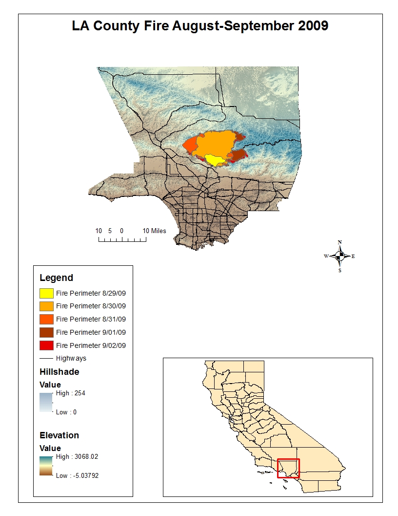
This first
map represents the area that the fire burned beginning on August 29, 2009 and
ending on September 2, 2009. Each
different color shows how the perimeter of the fire grew each day. This fire began on August 26, 2009 and the
cause of the fire was arson. In total
the fire burned about 160,000 acres of land.
It was the largest fire in recorded history of Angeles National Forest (“Station
Fire”). It can be seen on the map that I
created how quickly the fire was spreading.
Geography is a very important tool, an especially so in this situation
because it provides useful information about the affects of the fire. One application of using maps of this fire to
acquire and analysis information is studying the potential sediment
impact. In a brief written about this
fire and the study of the impact of sediment in the area stated, “The Station Fire
burned area, which spread across numerous Debris Production Areas, is
subdivided into 74 subarea watersheds” (Woods), the article then proceeds to
direct the reader to an attached map.
This is one example of an application of the importance of geography and
natural disaster.
The second
map also shows the daily fire perimeters as well as the major cities, smaller
cities, hospitals and highways that were affected. In observing this map it can be seen how
large of an impact this fire had on the city.
It burned through a major highway and was very close in proximity to
many cities and hospitals. An article
written on August 31, 2009 stated, “More than 12,500 homes were threatened, and
6,600 were under mandatory evacuation orders Sunday night.” (“L.A. County Fire
Doubles in Size”). This statistic alone
represents the impact of this fire, which is supported by this map.
The Station
Fire of 2009 was a very large fire that impacted many cities and therefore
people. It burned a huge area of
land. The tool of GIS is so helpful in
situations such as natural disaster because they can be used to outline the
affected areas and studied to see the impacts that the fire will have on
surrounding areas. It is important
information to know what cities, roads and hospitals will be affected, which is
why I thought that would be important to display these landmarks on my
map.
Works Cited
"L.A. County
Fire Doubles in Size; More Homes Destroyed; Mt. Wilson Threatened
[Updated]." Los Angeles Times. Tribune, 31 Aug. 2009. Web. 8 June
2012. .
"Large Fires
Natural and Inevitable in Southern California." The California
Chaparral Institute. N.p., 4 Sept. 2009. Web. 8 June 2012.
.
"Station
Fire." InciWeb. N.p., 10 Nov. 2009. Web. 8 June 2012.
.
United States.
The Natural Resources Agency. Department of Water Resources. CA.gov
Department of Water Resources. By Arnold Schwarzenegger, Mike Chrisman, and
Lester A. Snow. N.p., 30 Nov. 2009. Web. 8 June 2012.
.
Woods, Patricia.
"Station Fire Burned Area Brief." Letter to Christopher Stone. 14
Jan. 2012. Los Angeles County Department of Public Works. N.p., n.d.
Web. 8 June 2012.
.